-

Walking Trails
Eamonn A Chnoic Loop
More...
- Walking Trails
- Clare Glens
- Glenstal Wood
- Keeper Hill Trek
- Kilcommon Loop
- Knockalough Loop
- Eamonn A Chnoic Loop
- Birch-hill Loop

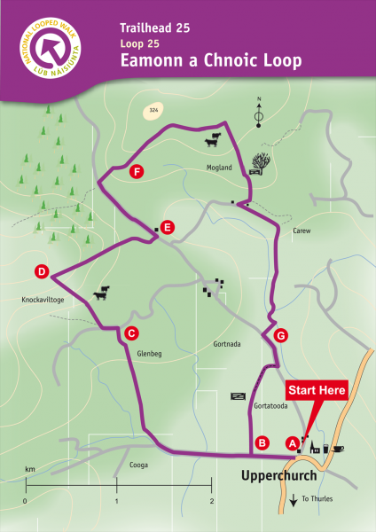
Eamonn A Chnoic Loop
Ascent: 150m
Distance: 8km
Estimated Time: 2hr30mins – 3hrs
Grade: Moderate
Minimum Gear: Walking boots, rain gear, snack and fluid
Services: Upperchurch village
Start and finish: Upperchurch village, Co. Tipperary. Map Ref: OS59 R987 613
Terrain: Minor roads, old laneways and fields
Theme: Nature
About:
Upperchurch is located near Thurles in Co. Tipperary and is twinned with the neighbouring parish of Drombane for many aspects of life including hurling (a traditional Irish sport played with sticks and ball). The community has been involved for many years in developing tourism products including hillwalking. This loop takes its name from a Robin Hood figure who roamed the hills of West Tipperary in the 17/18th century. His ancestors were extensive landowners, whose lands were confiscated. The young Eamonn was sent to France to study for the priesthood but he returned to his native country, and soon became involved in a fracas with a tax collector and shot him. Forced to go on the run, Eamonn a Chnoic (Ned of the Hill) became one of a band of rapparees who championed the cause of the poor, dispossessed natives and harassed the English planters. Many legends are told of these men and their deeds have passed into the folklore of the area.
Routes
A-B. Starting facing the Community Centre, follow the tarred road which goes left out of the village. After 300m you reach the Church Bog project on your right (wooden railings). This is the point at which you will exit the loop on your return. Continue straight here.
B-C. Follow the tarred road for 500m to reach a stone bridge and a stile on your right. Turn right here, entering the field, and follow the boundaries of the fields and a series of stiles as you ascend Glenbeg. At the top of the ascent you join an old roadway. Turn left here.
C-D. Follow the roadway for only 100m before turning right onto an old track and, after 50m cross a stile to join a ‘green’ laneway. The laneway fizzles as you make your way to the edge of forestry where you turn right.
D-E. Continue along the forestry boundary watching out for the traces of a fulacht fia (a mound of soil with a slight depression at its centre which acted as a cooking pit in the Bronze Age) on your right. After 500m you join an old laneway which takes you downhill to reach a tarred road at the side of a house. Turn left here.
E-F. Follow the tarred road for 300m before turning right onto an old laneway. Follow this to the edge of forestry where the loop crosses a ditch and follows the edge of the plantation. Reaching the corner of a field, the loop turns sharp right and downhill.
F-G. Continue downhill to reach an old laneway in the townland of Carew where you turn left and, after 100m, turn right again. Crossing a number of watercourses and a stream, you exit on a tarred surface and turn left.
G-A. After only 100m the loop turns right onto a laneway and through the townland of Gortatooda . At the end of the laneway, you cross a stile and traverse a field to reach the Church Bog project mentioned at B above. Exit via the wooden gate, turn left and enjoy the remaining 300m back to the trailhead.


